
From Sesto Calende to Milan on foot and by bike
Sixty six kilometres, in safety, within the Ticino Park, along canals and waterways, the River Ticino and the Via Francisca del Lucomagno. It is surrounded by nature, art and history.
The distance from Sesto Calende to Milan is 76 km and is entirely safe, accessible and without any slopes. This walk, or bike ride, is one in which you will discover a unique cross-section of Lombardy, with its rivers, dams, pieces of history, villas and historical roads. The route is largely within the Ticino Park, which is now part of the MAB (Man And the Biosphere) area, which includes the Verbano area, the regional Campo dei Fiori Park and the Val Grande National Park too.
The route starts from the tow path on the River Ticino in Sesto Calende, entering the Villoresi Canal after the Panperduto Dam, then the Naviglio Grande in Turbigo and, from there, to Abbiategrasso (in Castelletto di Cuggiono it crosses the Via Francisca del Lucomagno). In the town, it continues along the Naviglio Grande and arrives in Milan.
THE ITINERARY
Sesto Calende –Miorina Dam 3.4 km
Panperduto Dam 10.4 km
Tornavento 22.6 km
Turbigo 31.0 km
Castelletto di Cuggiono 37.6 km
Abbiategrasso 55.0 km
Milan 76.0 km
It is possible to travel along the whole route on foot or by bike, and it is accessible also to people with reduced mobility. When on foot, you may need to make several stops. For logistical reasons, linked to sleeping accommodation, it is possible to make the first stop in Panperduto, where there is a hostel, or in Tornavento. From there, the second stop can be made in Castelletto di Cuggiono, then in Morimondo and finally in Bereguardo.
If you are on the bike, there are two possibilities. As the route is completely flat, it is possible to travel in just one day, or to stop in Castelletto di Cuggiono, where there is low-cost sleeping accommodation.
From Sesto Calende to the Miorina Dam
The first, short section is 3.4 km long. You can start in the centre of Sesto Calende, and continue along the River Ticino. It is a beautiful walk if you want to discover the relationship between nature and the work of man. Immediately after the dam, you will find beaches and, higher up, the archaeological area of Golasecca.
From the Miorina Dam to Panperduto
This section also runs along the Ticino River, and is 7 km long. Along the tow path, as well as some bars, you will find the hydroelectric power plant of Porto della Torre and the first bridge that connects Lombardy and Piedmont, along State Road 336. “This place will enchant you,” according to the Panperduto website. “Here, water is the main feature, you can feel its magnificence and power; your gaze will be attracted by the complexity of the paths it takes from the river, how it’s redirected and channelled. Here, human ingenuity has succeeded in taming the water by building one of the most important hydraulic junctions in Lombardy, where part of the water from the River Ticino is diverted to form two very important canals: the Canale Villoresi, which is used for irrigation, and the Canale Industriale, which is essential for energy production. The Panperduto Dam on the Ticino and the associated works were inaugurated in 1884, following the project by Eugenio Villoresi, after several years of research and variations”.
From Panperduto to Tornavento
This section is 12.2 km long. You leave the Ticino tow path and start walking beside the Canale Villoresi, and come to just below the former Austro-Hungarian customs house, which is now the headquarters of the Ticino Park. Here it is worth stopping to discover the beauty of Via Gaggio, a sort of open-air history museum, and the panoramic viewpoint of Tornavento, an enchanting hamlet with a breath-taking view over Piedmont and the Alps.
From Panperduto to Tornavento
From Tornavento to Turbigo
This section is 8.4 km long. Be sure to take the towpath of the Villoresi canal, which leads to Monza. Turbigo has an ancient history, which dates back to Roman times. You can find a lot of details on the council website. In this territory, you will find the Turbigo thermoelectric power station, which was powered up for the first time in 1928. It covers an area of 56 hectares, located on the right bank of the Naviglio Grande.
From Turbigo to Castelletto Cuggiono
This section is 6.6 km long. Leave the Canale Villoresi to proceed along the towpath of the Naviglio Grande. This navigable canal was created by taking water from the River Ticino near Tornavento, and it ends in the Porta Ticinese Dock, in Milan. It has a total height difference of 34 m, over a distance of 49.9 km. Between Tornavento and Abbiategrasso, it varies in width from 22 to 50 m, and between Abbiategrasso and Milan, it narrows to 15 m, reducing to 12 m in the final section. The flow rate at Turbigo 64 m³ per second in the summer, and 35 m³ in the winter.
In Castelletto di Cuggiono, you will find the Via Francisca del Lucomagno, an ancient historical route that starts in the centre of Europe, in Constance, and continues on to Pavia.
From Castelletto di Cuggiono to Abbiategrasso
The section is 17.4 km long, all along the towpath of the Naviglio Grande. Along the route, you can find very interesting, villages. Continue on to Bernate Ticino, where you can admire the Rectory of San Giorgio. One of the gems of this section is Boffalora Sopra Ticino, a small village that is rich in history, that owes its growth to its proximity to the Naviglio Grande, as does Robecco on the Naviglio, where there are numerous villas. Before arriving in Abbiategrasso, there is Cassinetta di Lugagnano, one of the oldest villages in the Po Valley, where you can admire a statue of Charles Borromeo, who passed through these parts shortly before his death.
Some sections of the Naviglio Grande are navigable. Useful information can be found on this website.
From Abbiategrasso to Milan
This section is 21 km long. Although the route runs for the most part close to inhabited areas, it offers enchanting views. The first 11 km to Gaggiano is along a cycle path, which is suitable for everyone. The view is very characteristic, because you can enjoy how the colours of nature change over the year. Even during the days when the fog transforms the colours into various shades of grey, the landscape lends itself wonderfully to being photographed. During spring days, the Naviglio Grande is a perfect route for the classic, out of town cycle ride. The waterway ends at the Porta Ticinese Dock, in Milan.
USEFUL INFORMATION AND LINKS
The Ticino Park was created in 1974 to protect and safeguard the environment of the Lombardy Region along the River Ticino. It extends from Lake Maggiore to the point where it meets the River Po, on a total area of about 92,000 hectares, in 47 municipalities in the provinces of Varese, Milan and Pavia. Thanks to its heritage of nature, landscapes, art and history, the Ticino Valley was recognised by UNESCO as a Biosphere Reserve, in 2002. It has a dense network of paths, which cover the entire area of the park.
This is an ancient historical path that starts in Constance and reaches Pavia, covering 510 km. It enters Italy in Lavena Ponte Tresa, on Lake Ceresio, and from there, over 135 km, an eight-day walk brings you to Pavia. It meets this route in Castelletto di Cuggiono, and from that point on, the two routes coincide. We recommend you visit the Francisca website, for further information, also on accommodation.
HOW TO ARRIVE AND RETURN
The best way to get to Sesto Calende is by train with Trenord. Here is the website, which contains the timetables and ticket prices. The same can be done once you arrive in Milan. On several sections of the route, you will encounter villages, where there is a railway line.
Translated by Ilaria Bizzotto and Nicole Dall’Osto
Reviewed by prof. Rolf Cook
Dalla Home

Somma Lombardo
Si è ribaltato un altro grosso tir, traffico in tilt tra Somma Lombardo e Malpensa lungo la via Giusti

Varese
No alle manifestazioni di estrema destra a scuola, presidio sotto la pioggia all’Itet “Daverio Casula Nervi”
Varese
Il processo a Francesco Tomasella, in aula a Varese lette le chat con la ex: “Nel Medioevo saresti finita al rogo“
Economia
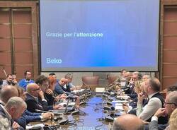
Cassinetta cuore dell’innovazione. Beko firma l’accordo e investe nel rilancio industriale italiano
La community di VareseNews
Loro ne fanno già parte
Ultimi commenti
andreabianchi su Donazione di organi, cresce il numero dei "no": i dati del Varesotto comune per comune
Giovanni Petrotta su "Sono scivolata e caduta a causa dei buchi sulla ciclabile Luino - Grantola"
Felice su La triste carica dei 107: oltre cento cani in gabbia in una villa a Buguggiate
MARINAMDG su Tarip, le prime fatture fanno discutere. Coinger: "Una rivoluzione culturale"
AF--67 su Tarip, le prime fatture fanno discutere. Coinger: "Una rivoluzione culturale"
Ora-SiempreResistenza su Scambio acceso tra studente e presidente Anpi a margine di un incontro scolastico a Luino


Accedi o registrati per commentare questo articolo.
L'email è richiesta ma non verrà mostrata ai visitatori. Il contenuto di questo commento esprime il pensiero dell'autore e non rappresenta la linea editoriale di VareseNews.it, che rimane autonoma e indipendente. I messaggi inclusi nei commenti non sono testi giornalistici, ma post inviati dai singoli lettori che possono essere automaticamente pubblicati senza filtro preventivo. I commenti che includano uno o più link a siti esterni verranno rimossi in automatico dal sistema.